exclave (noun) : a portion of a country geographically separated from the main part by surrounding alien territory
It is quite common for us to come across the word `enclave', a country or region that is completely surrounded or enclosed by the territory of another country. Examples of enclaves are :
1. Lesotho (enclaved by South Africa)
2. Vatican City (enclaved by Italy)
Before the re-unification of Germany in 1990, the city of West Berlin was also considered an enclave because it was surrounded by the former East Germany.
A logical extension of this concept is the 'exclave', where only part of a country or region is geographically separated from the main part by another territory. I have only recently found out what this word means and that there is an example in Peninsula Malaysia itself.
I was browsing Google Maps not long ago to look for interesting places to visit in Port Dickson, Negeri Sembilan. I noticed that the cape of Tanjung Tuan (also known by its Portuguese name of Cape Rachado) has a state boundary crossing it. I have been to this place before and loved the shallow beach known as Blue Lagoon (see post here -> Port Dickson) but I never realised that Tanjung Tuan is not in Negeri Sembilan. It is actually part of the state of Melaka.
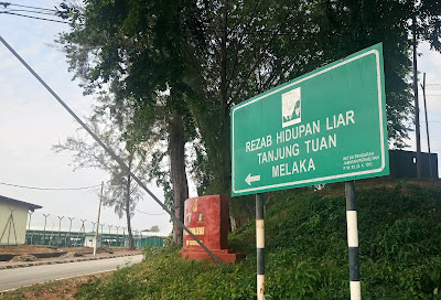
When I was in Port Dickson last week, I made a stop at Tanjung Tuan to take some photographs confirming this fact.
So there you have it. The small protrusion of hilly land extending its head to the sea known as Tanjung Tuan, which is mostly forest reserve and site of Cape Rachado Lighthouse is an exclave belonging to Melaka.
It has taken more than a half-century of my life to discover this. We learn something new every day...
 |
| The signboard on Federal Route 5, giving first indication that part of Melaka is isolated by Negeri Sembilan |
 |
| As we approach the cape, the state boundary signboard (right background) becomes evident |
 |
| The road on the left leads to the lighthouse (Melaka) while the one on the right leads to Pantai Tg Biru (Negeri Sembilan) |
 |
| The Google Map showing state lines cutting across the neck of the cape |
2 comments:
Bro..checkout Brunei DS and tell me if it's the same for the eastern territory
MS
Dear MS,
Wikipedia indicates that Brunei is a semi-enclave, the reason for which I'm still trying to comprehend.
Post a Comment